We are now over seven months into the PAGES project and considerable progress has been made
Much of my time after the July 2016 field season has been spent mapping and carrying out laboratory analysis on the sediment sequences that were sampled during the trip.
Geomorphological mapping forms a large part of my job as a PDRA on the project. The aim of the mapping in PAGES is to characterise the distinct lava flows that are exposed in the sides of the Hrazdan Gorge. Sandwiched between these are the sediment sequences which contain archaeological material, plus biological remains and chemical signatures that allow us to reconstruct past environmental conditions. Therefore, it is important to understand a) the relationship between the sediments and different lava flows, and b) the stratigraphy of the lava flows in the gorge, allowing us to understand the timing of volcanism and periods of hominin occupation in the area.
Most of the previous work I have done has focussed largely on mapping glacial features, over a much smaller area than that of the Hrazdan in Armenia. However, getting to grips with the latter has been great fun, although I have been subjected to a lot of map-based puns from my boyfriend (‘return of the map’, ‘it’s been a basalt on the senses’, to name a couple).
The process for mapping the lava flows is relatively straightforward, albeit that there are a number of stages involved.
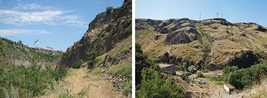
The first part of the mapping took place in the field. This entailed traversing sections of the Hrazdan from Ptghni (just north of Yerevan) to Solak (20 km north), and identifying the different lavas in the gorge. This is done on the basis of the lava structure and colour, but also on the basis of non-lava material between the lava layers (like sediments or types other volcanic deposits).
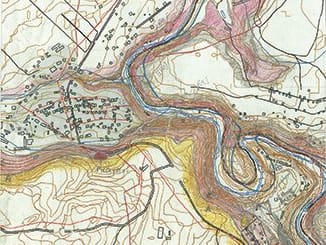
These distinct lava flows were then mapped onto topographic maps (see the illustration) and a GPS reading taken (where possible, some lavas are over 30 m above the valley floor and cannot be easily reached), allowing us to determine the exact position and elevation of the lavas once we returned to the UK. After each day's work in the field, the lavas identified were correlated to those from other parts of the Hrazdan, using a really high-tech method - shading in the maps with coloured pencils!
Back in the UK, the coloured-in topographic maps were geo-referenced, digitised and mapped onto a DEM (digital elevation model) of the area. The mapped heights and lengths of the different lavas were checked against the GPS readings taken in the field. Further 'desktop mapping' was also carried out using aerial imagery, allowing us to extend the field-mapped lavas to elsewhere in the gorge, plus identify potentially new lavas (which need to be checked in the field in July 2017).
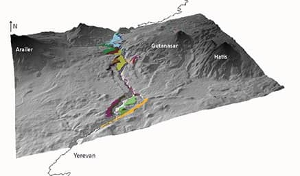
So far we have identified forty different lava flows in the gorge
We think six of these come from the Arailer volcano on the west side of the Gorge, with the rest emanating from the volcanoes in the Gegham range to the east. Using this information, we can now start to target specific lavas for argon-argon (40Ar/39Ar) dating and geochemical work, allowing us to determine their age, and possibly the volcano from which they originated. During our two field seasons in 2017, we will focus on finishing the mapping of lavas in the rest of the Hrazdan (from Solak to Lake Sevan), so by the end of 2017 we will have a full record of all of the lavas in the Hrazdan Gorge!
The views and opinions expressed in this blog are those of the author and do not necessarily reflect the position of the University.